Why do I need a Drone UXO Survey?
Drone / Aerial UXO Surveys are one of the most effective, safe and efficient means of detecting shallow-buried items of UXO / UXB on areas of relatively ‘clean’ Greenfield projects.
Depending on factors such as the size of the project site location, ease of access, nature of the identified risk and likely depth of targets – we can deploy a range of non-intrusive magnetometer survey techniques including manual walkover, vehicle-mounted or our Drone / Aerial UXO Survey system.
The survey is undertaken by a specialist two-person team and is normally a two-phase process, the first phase is the survey and then a Target Investigation Phase.
This survey approach is a well-tested and reliable process for minimising UXO risk on land and marine projects (for example: inland waterways and lakes).
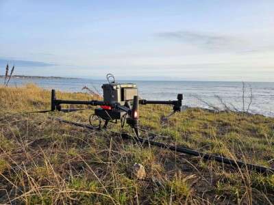
What is a Drone UXO Survey?
Specifically designed to be mounted on an Unmanned Aerial Vehicle (UAV), our magnetometer survey system can deliver excellent coverage, roughly 5 times more compared to traditional Non-intrusive UXO Survey methods – making it an attractive option for both speed and cost.
The system consists of an ultra-lightweight carbon fibre sensor tube with two built-in 3-axis fluxgates, data logger and integrated D-RTK GPS – and is well suited for difficult to access and restricted access projects.
The advanced magnetometer sensor has a 200Hz sampling rate, and can distinguish between motor noise, net frequencies, temporary interferences and ground signal – which allows it to be deployed directly beneath the drone without affecting the efficiency of the sensor.
All of our drone operatives carry PfCO qualification (Permission for Commercial Operation) and our Drone / Aerial UXO Survey systems have application approval under the Civil Aviation Authority (CAA).
What are the benefits of using a Drone / Aerial UXO Survey?
Best results are achieved by deploying the magnetometer sensor as close to the ground as possible, and our systems utilise both collision and obstacle detectors, and laser terrain following technology so that they can be flown autonomously – mapping a project site location area in a matter of hours!
Our manual / towed systems therefore provide the highest resolution data and are able to maximise the depths to which detection of discreet anomalies is possible.
In optimum ground conditions our Drone / Aerial UXO Survey system can detect a 50kg bomb at a max depth of 4m below ground level.
There are various benefits to utilising an aerial survey system Vs a manual walkover or vehicle-mounted non-intrusive survey:
- Fast to deploy and quick set-up time.
- Covers large areas which are difficult or not possible to survey on foot/by vehicle (For example: Marshy / partially flooded areas & Areas with access restrictions.
- Cost effective way of checking feasibility of ground-based Non-intrusive UXO Survey.
- Best suited for particularly clean and undisturbed Greenfield project site locations.
“It’s been a first class experience dealing with you and I would like to thank all of you for the excellent service. You have always been there to offer advice and support and you have bent over backwards to accommodate our ever changing circumstances.“
Project Manager, Clark Contracts
Explore our Case Studies
Case Study – East coast of Scotland
Looking to order a Drone / Aerial Non-intrusive UXO Survey?
Contact us for more details or to schedule a Drone / Aerial Non-Intrusive UXO Survey, our team of UXO specialists is ready to support your project.


 Audited")


